Free · nothing uploaded

Debrief your flight from its log.

Drop the data log of a Garmin G1000, G3000 or G3X Touch, of a JPI engine monitor, a Dynon SkyView or another flight deck, or a GPX or KML track. The analyzer replays the flight on a map, in 3D and on charts, assesses each approach and landing, finds the steep turns and flags exceedances. Your browser reads the file on your computer: nothing is uploaded.

Watch the film · 3 min 27

Read on your computer — the file never leaves it

Try a sample flight:

Synthetic flights, with a few mistakes made on purpose.

Drop a log above, or try the sample flight: the report appears here.

A film without commentary: music, and captions in English.

// THE FILM

The analyzer and ETEP Flights, in three and a half minutes.

From the log you drop to the planning of a club: the replay in 3D, the cockpit video in step, approaches and landings, the logbook, licences, and the Android application on its way.

// FREE ACCOUNT

Keep your flights with ETEP Flights.

This page forgets your flight when you close it. With a free ETEP Flights account, every flight you analyse is kept, with your aircraft, their maintenance and your licences. You sign in with a code sent by e-mail: no password.

Coming soon: Android and iPhone apps

Free up to 1 GB of logs and videos. Encrypted and hosted in France, shared with no one unless you choose to.

ETEP Flights logo: an aircraft and its track ETEP Flightsflights.etep.com
  • Your flights, kept. Every flight analysed and searchable: times, airfields, approaches, engine. Replay any of them here in one click.
  • Import by e-mail. Send your logs to your personal address: they are read on arrival, and you get a report.
  • Aircraft and maintenance. Hours and cycles counted from your flights, items due by hours, cycles or date.
  • Licences and currency. End dates of your licences and ratings, passengers and night over 90 days, SEP revalidation.
  • Instructor, club, link. Share your flights with whom you choose, and withdraw access at any time.
  • Glider, helicopter, drone. Thermals, set-down sites, batteries and drone missions.

// ETEP FLIGHTS IN FULL

For pilots, instructors and clubs.

More than a place to keep your flights: a logbook that fills itself, your licences checked against each aircraft, the planning of your club and the accounts of its pilots.

For the pilot

  • Logbook. Your analysed flights go in by themselves. Carry over your paper logbook, import another logbook (CSV or Excel) or type a line. Totals by function, night, IFR and simulator.
  • What you can fly. Your licences, ratings and medical with their end dates; for each aircraft, what it requires and what is missing.
  • Currency. Landings, passengers and night over 90 days, SEP revalidation: you know when to fly again.
  • Progress and records. A landing score out of 100, stabilised approaches, your best landing, your best month.
  • Your ghost approach. In the analyzer, your best approach to the same runway is drawn beside today's.
  • Airfield passport and year in flight. The map of every airfield you have flown to, and your year, as an image to share.
  • Cockpit video. Synchronised with the flight in the analyzer, then kept with it: replay the flight with its video.

For instructors and students

  • Your students' flights. The student invites the instructor, who then sees their flights and progress and comments on them. Either of them can end it at any time.
  • Lessons on the planning. The student asks for a lesson, the instructor proposes or accepts it; each step is sent by e-mail.
  • Supervised solos. A student's solo is confirmed by an instructor.
  • Read-only links. Show a flight to whoever you choose with a link, and withdraw it when you like.

For clubs and schools

  • Aircraft and instructor planning. Bookings, lesson requests, absences, maintenance blocks; day and week views; nothing booked twice.
  • Licences checked at booking. The pilot's licences are compared with what the aircraft requires, and maintenance due is flagged: a warning or a refusal, as the club decides.
  • Airfield weather. Wind, gusts, crosswind and rain on the planning, against the club's limits.
  • In your calendar. Your bookings in Google Calendar, Outlook or Apple Calendar.
  • Closed from the flight. The recorded flight attaches to its booking: billed time (block, flight or hour meter), landings, fuel.
  • Pilot accounts. Rates per aircraft, wet or dry, membership fees, fuel paid by the pilot, minimum balance, export for the accounts.
  • Card payments. Members top up their account online; the money goes straight to the club's Stripe account.
  • Shared fleet and maintenance. Roles of administrator, instructor, mechanic, pilot and student.
  • Reports. Activity over a period, a drone operator's flight register, an aircraft file for its insurer.

Glider, helicopter, drone

  • Glider. Your thermals, and the best of each flight.
  • Helicopter. Your set-down sites, found from your flights.
  • Drone. Missions, batteries and the operator's flight register.

// OFFERS

Free to start. 10 GB or 100 GB when you need more.

Free

€0 for as long as you like

  • 1 GB of logs and videos
  • Logbook, licences, currency, progress
  • Join your club's or school's organisation
  • Export your whole account
Create my free account  →

30-day trial offered

10 GB

€6.90 a month, or €69 a year

  • 10 GB of logs and videos
  • Read-only links of 30 and 90 days
  • PDF reports and video clips
Choose this offer  →

100 GB

€29 a month, or €290 a year

  • 100 GB for your videos
  • Your club's or school's organisation: planning, pilot accounts, card payments
  • Everything in the 10 GB offer
Choose this offer  →

Prices include taxes. 30 days of 10 GB offered with your first video, with no payment method. Each pilot who joins through your link adds 500 MB, up to 5 GB. Cancel at any time: nothing is deleted at the end of an offer. Terms of sale  →

// WHAT THE ANALYZER LOOKS AT

From one file, the debrief an instructor would make.

A Garmin integrated flight deck writes a row every second to the SD card: position, altitudes, speeds, attitude, accelerations, engine. The analyzer reads every row and builds the debrief from them.

Replay

The flight on a map coloured by phase, or in 3D over the terrain from a chase, cockpit or free-orbit view; an attitude indicator and the readings at the cursor, and charts of every parameter in the log. Play it back at the speed you choose, or click any point of the track or of a chart.

Approaches and landings

Each approach is checked from 500 ft above the field: sink rate, speed held, bank on short final, and the deviations of the guidance when the log has them. Each touchdown gets its sink rate, load factor, speed, flare distance and roll.

Steep turns

Each turn banked past 35° over at least 180° is measured against the practical-test tolerances you set: bank held, altitude kept, speed kept.

Exceedances and engine

Bank, pitch, load factor, speed limits you enter, cylinder heads cooling too fast, and your own rules on any column of the log, such as a CHT or an oil temperature limit.

The analyzer is a debriefing aid. It is not an approved flight data monitoring programme and does not replace an instructor's judgement or the aircraft flight manual. Heights are worked out from the log, without a radio altimeter.

// GOING FURTHER

D.T.MUX Viewer, the universal viewer for flight test and flight recorder data.

This page debriefs one avionics log in your browser. For flight recorders and flight-test recordings, D.T.MUX Viewer, for Windows, goes further.

  • Flight recorders. Raw ARINC 717 files from a QAR or a DFDR, ARINC 767 (EAFR) files, ARINC 657 downloads (.rso) and Chapter 10 recordings from any recorder, decoded with the aircraft's frame definition (FRED).
  • Video and audio on the same timeline. The cockpit camera, the cabin audio and the data, recorded together by ETEP recorders, replay in step.
  • The weather of the flight, in 3D. Atmospheric model, ground radar, lightning, METAR and TAF at the time of the flight; nothing is requested from the network without your consent.
  • A library of your flights. One row per flight, your own indicators and events with your thresholds, a fleet view and an Excel export.
  • Traceable analysis. The SHA-256 hash of each recording, a manifest beside each export, the session log and the test report.
  • A debriefing clip. Videos, 3D flight, PFD and curves composed into one MP4 video, frame by frame.

Free with ETEP equipment; recordings from other manufacturers open with D.T.MUX Viewer Professional, with a 30-day free trial. The Viewer does not read light avionics logs yet (Garmin, JPI, Dynon…): they are debriefed here.

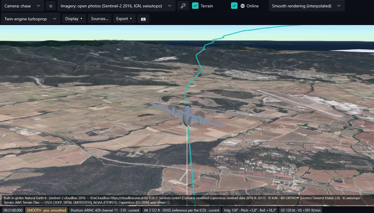
D.T.MUX Viewer 3D flight view: a generic twin in the chase camera above the terrain and the imagery, with its trajectory.
D.T.MUX Viewer: the 3D flight view.

// QUESTIONS

About the analyzer

What is ETEP Flights?

The free online account of this analyzer, at flights.etep.com: your flights kept and searchable, your aircraft and their maintenance, your licences and recent experience, shared with your instructor or your club if you wish. You sign in with a code sent by e-mail. Free up to 1 GB of logs; logs encrypted and hosted in France.

Is my file uploaded anywhere?

No, unless you choose to keep it in your ETEP Flights account. Your browser reads the file on your computer and no byte of it is sent to ETEP or to anyone else. The base map, the terrain (3D view and profile under the altitude), the aerial imagery and the METARs are the only things loaded from the network, each only if you accept it: the OpenStreetMap server then sees the area displayed; the terrain service (Amazon), a rectangle around the flight rounded to half a degree; the aerial imagery you may choose (official orthophotos of France, Germany (by Land), Spain, the Netherlands, Austria, Luxembourg, Switzerland, the Northern Ireland coast and the United States, or Sentinel-2 imagery by EOX everywhere), the area displayed on the map and, in 3D, the same rectangle plus, in finer detail, a few kilometres around the recognised departure and arrival airfields (with "Full detail" ticked in 3D, the tiles around the aircraft, and so the area flown over); the METAR archive (Iowa State University), the codes of the airfields and the period of the flight; the satellite image of the day (NASA), the date and the area; the US radar (Iowa State University), the time to 5 minutes and the area — never your file or your track. If you accepted the site's audience measurement, it counts the functions used, never the file or its name.

Which files can I open?

The data logs of Garmin flight decks: G1000, G1000 NXi, G3000, Cirrus Perspective and G3X Touch (the .csv files of the data_log folder on the SD card: open the whole folder to see every flight at once). The files of JPI EDM engine monitors (.JPI: every flight of the file is listed); without a GPS, only the engine is shown. Dynon SkyView logs, Electronics International MVP-50 and CGR-30 flight files, GRT logs and the FLIGHT files of the Avidyne R9. ForeFlight track logs, Flightradar24 exports and ADS-B traces (readsb JSON), GPX or KML tracks with times, such as those exported by most navigation apps, and the IGC files of gliders, paragliders, hang gliders and microlights (for a soaring flight: launch, thermals with their climb, glides with their glide ratio). A track has no attitude, no airspeed and no engine data: the analyzer then works from the ground speed and the GPS altitude. Drones: ArduPilot logs (.bin, .tlog), PX4 logs (.ulg), DJI flight records (.txt; those written since 2021 are encrypted by DJI and cannot be read in the browser), Parrot flight files (PUD, GUTMA), Autel flight logs, and the CSV exports of drone log apps and services. Dynon, EI, GRT, Avidyne and ForeFlight files are read from their makers' documentation, Autel logs from open descriptions: if yours is not recognised, send it to us.

How do I get the log out of a G1000?

Put an SD card in the lower slot of the multifunction display before the flight. The G1000 writes one file per power-up in the data_log folder, named log_ followed by the date and time. Copy it to your computer and drop it here.

How does the analyzer decide that an approach was stable?

By default, below 500 ft above the field and down to 50 ft: a sink rate under 1,000 ft/min, airspeed within a 15 kt band, and bank under 15° below 300 ft; with a guided approach, the course and glidepath deviations under half scale. Every threshold can be changed under “Thresholds and rules”, to match your school's or your operator's procedures.

How is the landing score out of 100 worked out?

From the checks of the approach and the touchdown, each worth a number of points: the sink rate and the airspeed band on final, the bank, the course and glidepath deviations when the log has them, the sink rate and the load factor at the touchdown, and the touchdown zone once the runway is known. Points start to go at half of each limit, so keeping a margin pays, and are all gone at one and a half times the limit. An approach that was not stabilised is capped at 70, however good the touchdown. A go-around is never marked down, and a soaring trace or a track received on the ground (Flightradar24, ADS-B) gets no score: its touchdown is not precise enough. The score is an aid to the debrief, not an assessment of the pilot.

Why can heights be a few feet off?

A light-aircraft log has no radio altimeter. The analyzer takes the elevation of the field from the log itself, from the altitude read while the aircraft rolls on it, and works heights from it. The altimeter reads a little low in ground effect: the moment of touchdown is taken from the load factor peak when the log has one.

How is the runway identified?

From the OurAirports database (public domain): about 33,000 runways around the world. The runway whose centreline passes closest to the touchdown or the lift-off, in the direction flown, is the one used. When the database locates both ends of the runway, the analyzer measures the touchdown from the threshold, the height over the threshold and the runway left, and checks that the touchdown is in the first third of the runway. When it only knows the airfield and the heading of the runway, it names the runway without measuring. Your browser loads the database whole, so it tells us nothing of where you flew.

My avionics is not recognised: what can I do?

Send us a sample log through the link shown under the drop area: we add new formats as they come. It is the only case where a file leaves your computer, and only if you send it yourself. The files it reads today are listed in the answer above.

Does it work for helicopters?

Yes. A helicopter is recognised from the rotor speed in its log or from a vertical lift-off, and you can also choose it in the settings. With the torque in the log, the analyzer tells a hover from the ground; without it, a hover in ground effect counts as on the ground. It then shows the hovers, the hover-taxi, the quick stops, the practice autorotations, the set-downs on a slope or off an airfield, and alerts of its own: fast descent at low speed (vortex ring), slow flight at low height (height-velocity diagram), fast descent or steep bank near the ground. Working definitions, to be agreed with your instructor.

Does it work without a connection?

Yes, once the page has been opened on this device: it keeps its own files (never yours) so that it opens at the airfield without a network. The base map, the terrain and the METARs still need the network.

How are night time and the height above the terrain worked out?

Night: the sun more than 6° below the horizon where the aircraft is (civil twilight), as EASA and the FAA log it; the logbook export also counts the night landings in the sense of FAA 61.57 (from one hour after sunset to one hour before sunrise). Height above the terrain: the logged altitude minus a public elevation model with a grid of about 30 m. It is indicative and is no terrain awareness system.

Are my thresholds kept?

Yes, in this browser only. They are not sent anywhere. “Restore the defaults” brings back the values above.

Garmin, G1000, G3000 and G3X Touch are trademarks of Garmin Ltd. or its subsidiaries. Cirrus Perspective, JPI, EDM, Dynon, SkyView, Electronics International, MVP-50, CGR-30, GRT, Avidyne, Entegra, ForeFlight and Flightradar24 are trademarks of their respective owners. ETEP is not affiliated with these companies; the analyzer reads the files their products write.

Display settings

Kept in this browser only. Thresholds and rules stay in aviation units; the cockpit tapes too.

An image of this flight to share

The image is made in your browser: nothing is sent to ETEP. A map background is fetched from EOX or OpenStreetMap, whose credit is printed on the image.

Record the cockpit video with the data.

For a training fleet, the Sentinel ED-155 records the aircraft data, the cockpit camera and the cabin audio together, and D.T.MUX Viewer replays them on one timeline for the debrief.

Discover the Sentinel ED-155  →